
Unique Maps
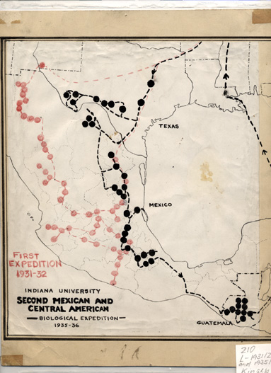
Title: Indiana University Second Mexican and Central American Biological Expedition
Publisher:
Date of map: 1931-1932; 1935-1936
Notes: Map shows Mexico and portions of the southern United States and Central America. The map shows two expeditions through these areas and denotes where stops were made and galls collected. The trips and years are First Expedition 1931-32 (in red pencil) and Biological Expedition 1935-36.
A biographical narrative of these two Mexican trips appears in Cornelia V. Christenson's Kinsey: A Biography. Bloomington: Indiana University Press, 1971: pp. 62-84.[IUCat]
and Central American Biological Expedition
Title: Lake Tahoe and Vicinity: California-Nevada
Publisher: U.S. Geological Survey
Date of map: 1901?
Notes: This 1:125,000 scale map of Eastern California and Western Nevada has been trimmed to exclude publication data information. The edges of the map have been taped and the body of the has been backed with canvas for increased durability. Lake Tahoe, Donner Lake, Washoe Lake, and others have been outlined in black marker. Other areas on the map have been marked black, mostly in regions northwest and southwest from Lake Tahoe, likely denoting the location of found wasp samples.
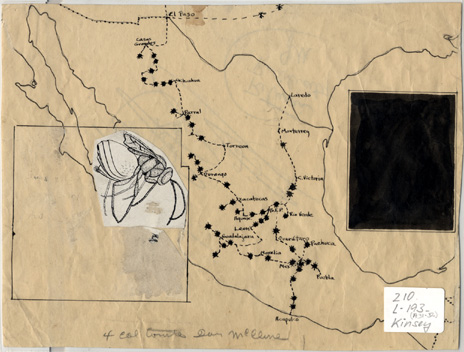
Title: No title
Publisher: Kinsey
Date of map:
Notes: This map shows most of Mexico and portions of southern Texas. There are two squares on the left and right sides of the map. One square is a solid black square and the other one is just an outline with a wasp, which has been pasted on the map, in the upper right hand corner. The map seems to show a trip taken through Mexico with stars showing different stops and names where gall samples were collected. All of the stops seem to correspond to the first expedition featured in the map listed above.
Title: Standard Map of Illinois: Main Highway Map of Illinois & Principal Trails in Illinois / Illinois Railroads (two-sided)
Publisher: Rand McNally & Company, Chicago.
Date of map: Unknown
Notes: This transportaion map is signed "Alfred C. Kinsey 1-17-25" and cataloged as 830 D-1925 Kinsey.
Title: United States Contour Map
Publisher: U.S. Geological Survey
Date of map: 1906, reprinted 1925
Notes: Map has different numbers of black dots in all 48 contiguous states. This map is strikingly similar to the map created by Dr. Kinsey to denote the location and number of interviews made for his book Sexual Behavior in the Human Male (Bloomington call number: HQ28 .K55 1998). The map and its representation from the book are pictured below.
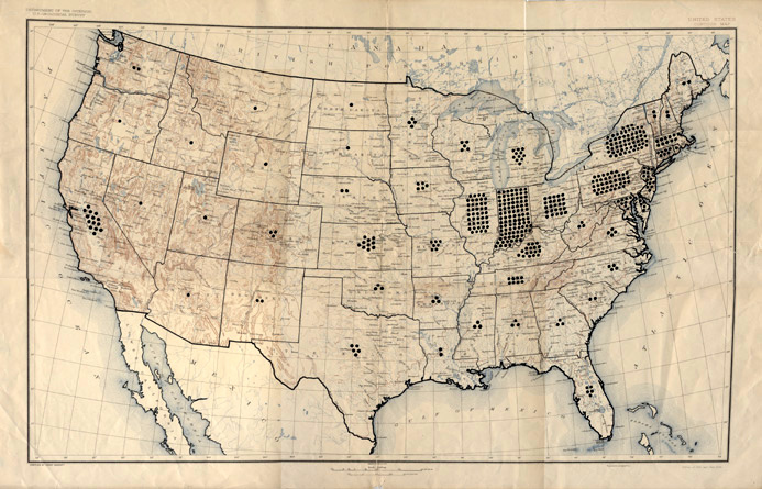
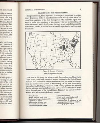
Sexual Behavior in the Human Male.
Title: United States of America prepared especially for The National Geographic Magazine
Publisher: The National Geographic Society
Date of map: 1923
Notes: A full-color 1:5,250,000 map of the contiguous United States with insert maps of the following cities: Seattle, Portland, San Francisco, Los Angeles, Chicago, New Orleans, Baltimore, Detroit, Washington, Cleveland, St. Louis, Pittsburgh, Philadelphia, Buffalo, Boston, and Greater New York.
U.S. Geological Survey Maps
The following maps of the contiguous U.S. are labeled for a specific class of tree or gall. Red dots on each map denote where the gall specimens were obtained.
Title: United States
Publisher: U.S. Geological Survey
Date of map: May 1906, reprint 1922
Notes: Labeled Pinus Albicaulis small red dots have been painted on the map.
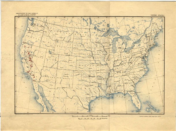
Title: United States
Publisher: U.S. Geological Survey
Date of map: March 1911, reprint 1923
Notes: Labeled Pinus Contorta; small red dots have peen painted on the map.
Title: United States
Publisher: U.S. Geological Survey
Date of map: May 1906, reprint 1922
Notes: Labeled Pinus Monticala and small red dots have been painted on the map.
Title: United States
Publisher: U.S. Geological Survey
Date of map: May 1906, reprinted 1922
Notes: Labeled Pinus Lambertiana and small red dots have been painted on the map.
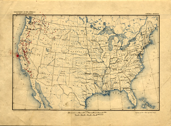
Title: United States
Publisher: U.S. Geological Survey
Date of map: March 11, reprinted 1923
Notes: Labeled Pinus Ponderosa. Red dots have been painted on the map denoting where gall samples were procured.
Title: United States
Publisher: U.S. Geological Survey
Date of map: March 1911, reprint 1923
Notes: Labeled Pinus Jeffregi. Red dots have been painted on the map denoting where gall samples were procured.
Title: United States
Publisher: U.S. Geological Survey
Date of map: May 1906, reprint 1922
Notes: Map has 3 groups of symbols at the bottom and labels on the map in different colors.
Title: United States
Publisher: U.S. Geological Survey
Date of map: May 1906, reprinted 1922
Notes: Map B1: labeled Neuroterus Niger and has labels listed at the bottom with different colored symbols that correspond to symbols on the map.
Title: United States
Publisher: U.S. Geological Survey
Date of map: May 1906, reprint 1922
Notes: Map B2: labeled Neuroterus Saltatorius. At the bottom of the map are several labels with different colored dots that correspond to colored dots on the map.
Title: United States
Publisher: U.S. Geological Survey
Date of map: May 1906, reprint 1922
Notes: Map B3: Labeled Neuroterus Quericola. At the bottom of the map are several labels with different colored dots that correspond to colored dots on the map.
Title: United States
Publisher: U.S. Geological Survey
Date of map: May 1906, reprinted 1922
Notes: Map B4.: Labeled Neuroterus (Diplobius)Floricola, Kinsey and has one red dot at the bottom of the map and a red dot in Calafornia.
Title: United States
Publisher: U.S. Geological Survey
Date of map: May 1906, reprinted 1922
Notes: Map B5.: Labeled Neuroterus (Dolichostrophus) decipiens, KINSEY. The Label has a red dot next to it and several red dots on the map in different areas of Calafornia.
Title: United States
Publisher: U.S. Geological Survey
Date of map: May 1906, reprinted 1922
Notes: Map B6.: Labeled Neuroterus (Dolichostrophus) dubius, Basset. At the bottom of the map are several labels that with different colored symbols that correspond to colored symbols on the map.
Title: United States
Publisher: U.S. Geological Survey
Date of map: May 1906. reprint 1922
Notes: Map B7. Labeled Andricus Californicus, BASSET. At the bottom of the map are several labels with different colored dots that correspond to colored dots on the map.
Title: United States
Publisher: U.S. Geological Survey
Date of map: May 1906, reprinted 1922
Notes: Map B8. Labeled Andricus Lasius, ASHMEAD. At the bottom of the map are three labels with diffrent colored dots that correspond to colored dots on the map.
Title: United States
Publisher: U.S. Geological Survey
Date of map: May 1906, reprint 1922
Notes: Map B9. Andricus Pomitormis, Bassett. At the bottom of the map are several labels with diffrent colored dots that correspond to colored dots on the map.
Title: United States
Publisher: U.S. Geological Survey
Date of map: May 1906, reprint 1922
Notes: Map B10. Labeled Andricus Ribes, KINSEY. Has a red dot next to the label and two red dots on the map in calfornia.
Title: United States
Publisher: U.S. Geological Survey
Date of map: May 1906, reprint 1922
Notes: Map B11. Labeled Andricus Spectabilis, KINSEY. At the bottom of the map are several labels with diffrent colored symbols that correspond to colored symbols on the map.
Title: United States
Publisher: U.S. Geological Survey
Date of map: May 1906, reprint 1922
Signed by Kinsey on:
Notes: Map B12. Labeled Compsodryoxenus Brunneus, ASHMEAD. Map has two red symbols at the bottom which are labeled and correspond to several symbols on the map.
Title: United States
Publisher: U.S. Geological Survey
Date of map: May 1906, reprint 1922
Notes: Map B13. Labeled Cynips Mirabilis , KINSEY. Map has a yellow dot next to the label which corresponds to several yellow dots on the map.
Title: United States
Publisher: U.S. Geological Survey
Date of map: May 1906, reprint 1922
Notes: Map B14, Labeled Diastrophus Kincaidii, GILLETTE. Map has two labels at the bottom with colored dots that correspond to dots on the map.
Title: United States
Publisher: U.S. Geological Survey
Date of map: May 1906, reprint 1922
Signed by Kinsey on:
Notes: Map B15 Labeled Diplolepis Bassetti, BEUTENMULLER. Map has two labels at the bottom with colored dots that correspond to dots on the map.
Title: United States
Publisher: U.S. Geological Survey
Date of map: May 1906, reprint 1922
Notes: Map B16. Labeled Diplolepis Fusiformans, ASHMEAD. Map has various colored symbols at the bottom with abels that correspond to colored symbols on the map.
Title: United States
Publisher: U.S. Geological Survey
Date of map: May 1906, reprint 1922
Notes: Map B17. Labeled Disholcaspis Simulata, KINSEY. Map has three labels with colored symbols at the bottom that correspond to colored symbols on the map.
Title: United States
Publisher: U.S. Geological Survey
Date of map: May 1906, reprint 1922
Notes: Map B18. Labeled Heteroecus Bakeri, KIEFFER. Map has two labels, one label has a green dot and the other has a red question mark. Several green dots and red question marks appear on the map.
Title: United States
Publisher: U.S. Geological Survey
Date of map: May 1906, reprint 1922
Notes: Map B19. Labeled Heteroecus Dasydactyli , ASHMEAD. Map has various labels at the bottom with colored dots that correspond to colored dots on the map.
Title: United States
Publisher: U.S. Geological Survey
Date of map: May 1906, reprint 1922
Notes: Map B20. Labeled Heteroecus Chrysolepidis, ASHMEAD. Map has two labels at the bottom, one with a green dot and the other with a red dot. Both correspond to several red and green dots on the map.
Title: United States
Publisher: U.S. Geological Survey
Date of map: May 1906, reprint 1922
Notes: Map B21. Labeled Heteroecus Melanoderma, KINSEY. Map has two labels at the bottow with red dots that correspond to dots on the map.
Title: United States
Publisher: U.S. Geological Survey
Date of map: May 1906, reprint 1922
Notes: Map B22. Labed Heteroecus Pacificus, ASHMEAD. Map has three labels at the bottom that have colored symbols that correspond to places on the map.
Title: United States
Publisher: U.S. Geological Survey
Date of map: May 1906, reprint 1922
Notes: Map B23. Labeled Heteroecus Sanctae-clarae, FULLAWAY. Map has three labels at the bottom with different colored dots that correspond to dots on the map.
Title: United States
Publisher: U.S. Geological Survey
Date of map: May 1906, reprint 1922
Notes: Map B24. Labeled Plagiotrichus Asymmetricus, KINSEY. Map has three labels at the bottom with different colored symbols that correspond to symbols on the map.
Title: United States
Publisher: U.S. Geological Survey
Date of map: May 1906, reprint 1922
Notes: Map B25. Labeled Plagiotrichus Chryoolepidicola, AHSMEAD. Map has labels at the bottom with different colored symbols that correspond to colored symbols on the map.
Title: United States
Publisher: U.S. Geological Survey
Date of map: May 1906, reprint 1922
Notes: Map B26. Labeled Plagiotrichus Perdens, KINSEY, Map has two labels at the bottom. One has a red dot and the other has a yellow dot and they correspond to red and yellow dots on the map.
Title: United States
Publisher: U.S. Geological Survey
Date of map: May 1906, reprinted 1922
Notes: Map B27 Labeled Plagiotrichus Suttonii, Bassett. Map has labels at the bottom with different colored dots and symbols that correspond to colored dots and symbols on the map.
Title: United States
Publisher: U.S. Geological Survey
Date of map: May 1906, reprint 1922
Notes: Map C1. Labeled Astragalinus Tristus The map has information at the bottom as well as labels with different colored dots that correspond to dots on the map.
Title: United States
Publisher: U.S. Geological Survey
Date of map: May 1906, reprint 1922
Notes: Map D1. Small portion of the label is missing. Intact lable reads Piluophis Catenife, BLAINVILLE, The map has multiple labels at the bottom with different colored dots that correspond to dots on the map.
Title: United States
Publisher: U.S. Geological Survey
Date of map: May 1906, reprint 1922
Notes: Map D2. Labeled Sceloporus Occidentalis, BAIRD & GIRARD, The map has several labels at the bottom with different colored dots that correspond to dots on the map.
U.S. Geological Survey Maps, by City and State
Title: Anniston, Alabama
Publisher: U.S. Geological Survey
Date of map: Nov. 1900 reissued 1918 with red overprint
Signed by Kinsey on: 4-16-25
Notes:
Title:Ashland, Alabama
Publisher:U.S. Geological Survey
Date of map: April 1891, reprinted 1921
Signed by Kinsey on:
Notes:
Title: Bessemer Iron District
Publisher: U.S. Geological Survey
Date of map: April 1907, reprinted August 1915
Signed by Kinsey on:
Notes:
Title: Birmingham, Alabama
Publisher: U.s. Geological Survey
Date of map: 1907, reprinted 1916
Signed by Kinsey on: 4-16-25
Notes:
Title: Birmingham, Alabama
Publisher: U.S. Geologcial Survey
Date of map: 1907, reprinted 1916
Signed by Kinsey on:
Notes:
Title: Brookwood, Alabama
Publisher: U.S. Geological Survey
Date of map: September 1899, reprinted June 1911
Signed by Kinsey on:
Notes:
Title: Clanton, Alabama
Publisher: U.S. Geological Survey
Date of map: April 1891, reprinted 1921
Signed by Kinsey on:
Notes:
Title: Columbiana, Alabama
Publisher: U.S. Geological Survey
Date of map: June 1911
Signed by Kinsey on:
Notes:
Title: Cullman, Alabama
Publisher: U.S. Geological Survey
Date of map: Surveyed 1885
Signed by Kinsey on:
Notes: Reconnaissance Map
Title: Dadeville, Alabama
Publisher: U.S. Geological Survey
Date of map: April 1906
Signed by Kinsey on:
Notes:
Title: Fort-Payne Alabama-Georgia
Publisher: U.S. Geologcial Survey
Date of map: September 1900, reprinted 1918
Signed by Kinsey on: 4-16-25
Notes:
Title: Gadsden, Alabama
Publisher: U.S. Geologcial Survey
Date of map: 1903, reprinted 1920
Signed by Kinsey on:
Notes:
Title:Gadsend (state not readable)
Publisher: U.S. Geological Survey
Date of map: September 1903
Signed by Kinsey on:
Notes: name written in as well as "[part of now Boaz, Rodentown, Howleton, and Gadsden]"
Title: Graveliy Springs, Alabama
Publisher: U.S. Geological Survey
Date of map: 1926
Signed by Kinsey on:
Notes:
Title: Huntsville, Alabama, Tennesse
Publisher: U.S. Geological Survey
Date of map: April 1892, reprinted February 1914
Signed by Kinsey on: Not Signed
Notes:
Title: IUKA MIssissippi-Alabama-Tennessee
Publisher: U.S. Geological Survey
Date of map: February 1914, reprinted 1927
Signed by Kinsey on:
Notes:
Title: Jasper, Alabama
Publisher: U.S. Geological Survey
Date of map: August 1893, Reprinted 1921
Signed by Kinsey on:
Notes:
Title: Montevallo, Alabama
Publisher: U.S. Geological Survey
Date of map: July 1910
Signed by Kinsey on:
Notes:
Title: Muscle Shoals, Alabama
Publisher: U.S. Geological Survey
Date of map: 1916
Signed by Kinsey on: Not Signed
Notes:
Title: Opelika, Alabama & Georiga
Publisher: U.S. Geological Survey
Date of map: February 1909
Signed by Kinsey on:
Notes:
Compiled and edited by Aaron Smith, Fall 2001, and William Cuthbertson, Fall 2004.
Geography and Map Library, Indiana University--Bloomington
Questions and comments: libgimms@indiana.edu
Copyright 1997, The Trustees of Indiana University
Return to Government Information, Maps, and Microform Services.
Location: