
About the Russian Military Topographic Map Collection
The IU collection of these (mostly) former Soviet Red Army topographic maps came to us from the duplicate map room of the Library of Congress Map Collection. While by no means complete, this collection is a fine addition to our existing international map holdings. These maps have a great story to tell: some carry the stamp from both the University of Berlin and the University of Bonn Geography Departments, some are stamped "Captured Map", some carry the ID of the CIA Map Library or the Bureau of Geographic Names, and still others are hand-annotated. They are in a variety of conditions (paper, laminated, photographically reproduced in color or black and white, plasticized, or muslin-backed). The collection ranges from around 1880-1945. You can read more about the collection in the National Geographic article, "See the Classified Russian Maps That Fell Into Enemy Hands".
The maps are indexed in a similar fashion to those of the International Map of the World Series, which means that they are indexed latitudinally beginning with the letter A at the equator and proceeding north at 4 degree increments to the letter Z at the north pole, and longitudinally beginning with the number 1 at the 180th meridian and proceeding east around the world at 6 degree increments until the number 60, which is the 180th meridian.
The US Army translated a guide to the symbols used on these maps. This guide can be viewed in the HathiTrust.
We have the German counterparts to these maps produced during WWII as well. They share much of the same information and are indexed in the same fashion. These, however, are not organized at the moment.
IUCat records: 1:25,000 maps , 1:50,000 maps , 1:100,000 maps
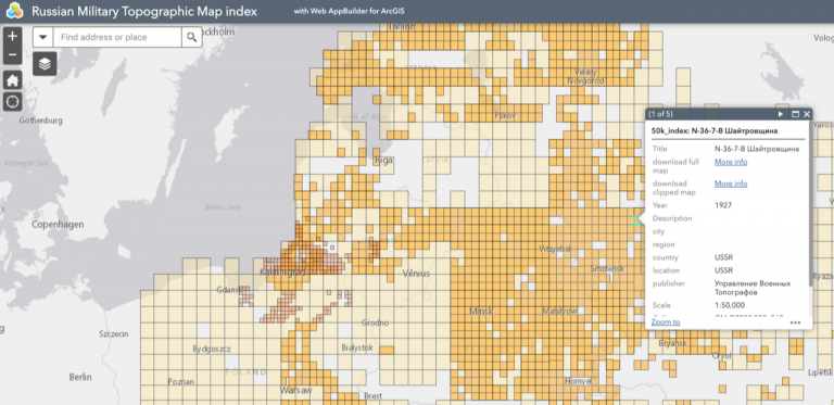
The Interactive Index
Indexed and available for download by the public, these maps may be accessed through the Russian Military Topographic Map index. You can also browse these maps through Indiana University's Image Collections Online.
The Old Index
Before our interactive map was finished, we made do by adapting paper indexes for the web. The original index maps were scanned copies of copies, and were extremely difficult to use (see example below).
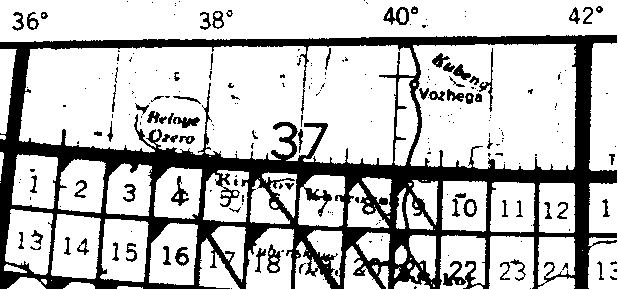
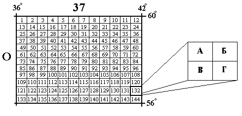
The small rectangles reading left to right numbered 1 through 12, 13 through 24, etc., (this pattern continues down--which is shown on the example below--until the number 144) represent one map at the scale of 1:100,000. For example, a map with the number O-37-1 is the first map in this area, O-37-2 is the second, and so on down to O-37-144.
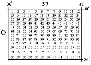
Each 1:100,000 scale map can be further subdivided into 4 maps at 1:50,000 scale:
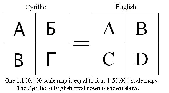
Their numbering scheme is just a continuation of the 1:100,000 parent map sheet. For example, O-37-132-A is the 1:50,000 scale northwest quadrant of the O-37-132 1:100,000 map.
Each 1:50,000 scale map can be further subdivided into four 1:25,000 scale maps. With the exception of just a few of this scale, all are in the N-34 area.
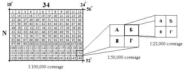
Their numbering scheme is also a continuation of the 1:100,000 and 1:50,000 parent map sheets. For example, N-34-132-A-a is the 1:25,000 scale northwest quadrant of the N-34-132-A 1:50,000 scale map.
Project Support
The digitization, georeferencing, and cataloging of the Russian Military Topographic Map Collection was supported by a Digitizing Hidden Collections grant from the Council on Library and Information Resources (CLIR). The grant program is made possible by funding from The Andrew W. Mellon Foundation.
The project team included:
Michelle Dalmau (PI), Head of Digital Collections Services
Theresa Quill (PI), Map and Spatial Data Librarian
Brianna Best, Image and Metadata Quality Control Specialist
Jordan Blekking, Image and Metadata Quality Control Specialist
Conner Capik, GIS and Digitization Specialist
Alexis Fain, Image and Metadata Quality Control Specialist
Kathrine Hastings, Image and Metadata Quality Control Specialist
Ardasher Khashimov, Cataloging & Digitization Specialist
Matthew Leetz, GIS and Digitization Specialist
Sam Szewczyk, Image and Metadata Quality Control Specialist
Veronika Trotter, Cataloging & Digitization Specialist
Sarah Ward, Image and Metadata Quality Control Specialist
With special help from:
Kara Alexander, Digital Media Specialist
Caitlyn Smallwood Hastings, Digital Imaging Specialist
Jennifer Liss, Head of Monographic Image Cataloging
Return to Government Information, Maps, and Microform Services.
Location: